If you have legs, or a bicycle, or indeed both, you are going to love this book. Chaps, no matter how old or how fat or otherwise incapacitated you are, if you haven’t already received it for Father’s Day the chances are it’s coming your way this Christmas. Ladies: if you are a fell-runner, a hill-walker or a budding Victoria Pendleton, pop this into your backpack or saddlebag with your energy bars and your old Ordnance Survey. Graham Robb — yes, that Graham Robb, the biographer and historian of all persons and all things French, and also the author of an excellent history of homosexuality, Strangers: Homosexual Love in the 19th Century (2003) — has written a book about British and Irish cols and passes. But wait: British and Irish whats?, I hear you townies ask.
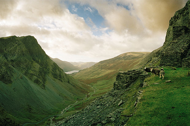
A col — sometimes known as a ‘hass’, a ‘hause’, a ‘swire’, a ‘nick’, a ‘sneck’, a ‘slap’, a ‘sloch’, who knew? — is defined by Robb as ‘a gap or depression in a ridge or a range of hills which serves as a gateway to the lands on either side’, and it is not, it is most certainly not, as Robb defiantly points out, despite ‘the hasty idiom of professional bike racing’, simply a term referring to the long steep climbs undertaken by panting riders in the Tour de France. A pass, inevitably perhaps, is rather more difficult to define, though poetically summed up by Robb as ‘a road which runs through a steep-sided valley of menacing demeanour’.
In France, notes Robb, cols are honoured with their own signs and map coordinates but
At some of the most impressive summits of the British road system, the traveller is greeted with nothing but instructions and advice: Keep Your Dog on a Leash, Lock Your Car, Take Your Litter Home.
Robb seems at least partly motivated in his work to outdo the French, since some years ago, apparently, the French Club des Cent Cols produced a list of the cols of the British Isles: they listed 533. Robb lists 2,002 cols and 105 passes and politely points out that at least several of the cols in the French list ‘are not actually cols’.
The work that has gone into this small, vast, perfectly formed and beautifully bound thing is quite incredible. Robb explains his process and procedures thus: first he found all the words ever used to refer to a col in the British Isles, using the 89-volume Survey of English Place Names, the archives coordinated by the ‘Scotland’s Places’ project, the Placenames Database of Ireland, the ‘name book’ of the Ordnance Survey’s surveyors and the larger toponymic guides and gazetteers; then he ‘read all the maps I could find’; then he visited the cols; and finally he compiled his catalogue entries with National Grid co-ordinates. And on the seventh day, presumably, he wrote his biographies of Victor Hugo, Rimbaud and Balzac.
Robb gets the geology out of the way pretty quickly — ‘cols were formed either gradually or violently, by glaciation, seismic activity or tectonic movement’ — before providing a guide to the regions and their cols, which allows him to exercise his rather sly, deadpan humour. The entry for London, for example, begins:
An enormous, overstuffed walrus… is one of many unique objects of the natural world displayed in the Horniman Museum in south London.
He also explains that
the Watford Gap… through which the River Thames flowed in the Pleistocene epoch, no longer has the clear characteristics of a col and is therefore not included in this catalogue.
The actual catalogue is neat, easy to use and organised first by country (England, Wales, Scotland, Northern Ireland, Republic of Ireland), then by county or council area, and in the case of the Highlands then by ‘lieutenancy areas’, since they have so many cols up there there’s no other way to do it. I remember that somewhere Robb described his work on Strangers as ‘a strangely merry adventure’. If anything, Cols and Passes of the British Isles is stranger and merrier still.


Comments