
Poperinghe, Bailleul, Wytschaete, Gheluvelt, Ploegsteert, Messines, Zonnebeke, Passchendaele. The other week I grandiosely claimed that I have been reading about the first world war, on and off, all my life. What I ought to have added was ‘with little or no understanding’. Because it wasn’t until a fortnight ago, when I bought a 1916 Ordnance Survey map of Belgium (Hazebrouck 5A), and consulted it while reading Anthony Farrar-Hockley’s account of the First Battle of Ypres, that I began to fix these blood-soaked villages in my mind.
The Second and Third Battles of Ypres were disputed over a few square miles. Stated objectives might be a slight promontory or a smashed village. Advances and retreats were measured in yards. Narrative accounts of these battles can therefore be followed with comparative ease. But First Ypres was a wide-ranging battle of movement by the old British army and its cavalry. Frustrated by the pitiful maps included in General Sir Anthony Heritage Farrar-Hockley’s soldierly account, I searched eBay for a better one. Churchill said of the Ypres salient: ‘A more sacred place for the British race does not exist.’ My 100,000 scale Ordnance Survey map (1916) of our sacred place cost just 20 quid.
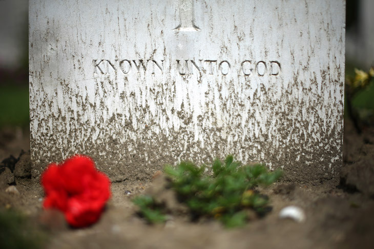
Several years ago I visited the salient on a battlefield tour, yet still I failed to grasp the geography. We’d hop off the coach next to a neat cemetery and piously inspect the gravestones and read the simple attributions carved in Eric Gill’s font. Then I would look around at the flat, agricultural landscape and wonder which way they were facing when they were killed. Then we would hop back on the coach and move on to the next one. Hill 60, Essex Farm, Sanctuary Wood, Langemark, Tyne Cot — always the same spick and span rows and the same puzzle. I could have asked the retired Grenadier Guards colonel who led us, I suppose, if he knew where the front lines were situated. But this frightfully nice man seemed always on the verge of tears and I didn’t like to intrude on his grief. The half-dozen other tour members were as ignorant as I was.
After Ypres our coach took us to Vimy Ridge. The stark white monument to the dead Canadians stands on the lip of a great escarpment, with panoramic views of the Douai plain spread out below like a map. This battlefield tour was my second visit to Vimy Ridge. My first was a solitary pilgrimage made during the 1998 World Cup. And even after this second, guided visit my wholly mistaken, and in hindsight ludicrous belief persisted that the Canadians had gained the ridge by attacking from the plain below.
Next stop, the Somme. I got it all wrong here as well. In a leafy lane, for example, we hopped off the coach and inspected the unusually narrow Devonshire Regiment cemetery. It is narrow because after the Devons had leapt over the parapet on 1 July and were promptly mown down by a single German machine gun, it was simpler to chuck the corpses in the trench and fill it in. A stone inscription beside the wicket gate to the cemetery says: ‘The Devonshires held this trench; the Devonshires hold it still.’ Among the buried here is Captain Duncan Lenox Martin. A week before the battle Captain Martin spotted a hidden German machine-gun position which he accurately predicted would do for them all. Lying here too is the poet Lieutenant William Noel ‘Smiler’ Hodgson MC, who, before going over the top, wrote a prophetic poem called ‘Before Action’. The final line of the poem is: ‘Help me to die, O Lord.’
Above the Devons’ trench, a steepish hill runs upwards for 50 yards to a wood. I scanned the edge of this wood and wondered where the fatal machine gun was sited. It wasn’t until months later, when I looked online, that I realised that the German trenches were 400 yards away, and in exactly the opposite direction to the one I imagined, across an East Anglia-sized arable field then as now completely bare of cover. Our poor Guards colonel was so completely unmanned by the Devons’ cemetery that he stumbled around blinded by his tears.
So if you are thinking of going on a battlefield tour, get a bloody map. Gheluvelt, Zonnebeke, St Jean, St Eloi, Hooge, Pilkem, le Pilly, la Bassée, la Vallée — there they all are in familiar colours on my 1916 Ordnance Survey map, the tiny Flanders villages and hamlets and farms where the line was held, a quarter of a million casualties in the Third Battle of Ypres alone. Our sacred place.
Does it matter to me that our century-long disorderly retreat from that line of villages and hamlets is everywhere accelerating into a rout? Or that one has only to walk past a radio tuned to BBC Radio 4 to know it? It doesn’t bother me at all. On the contrary, I’m excited.


Comments