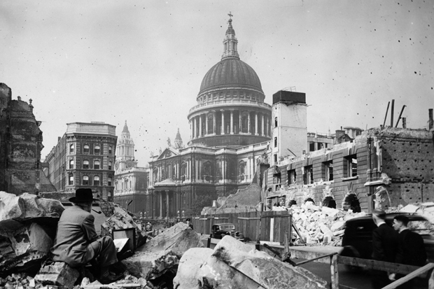
While the Germans were raining bombs on London during the second world war, the architects’ department of London County Council was busy colouring in Ordnance Survey maps of the city to record which buildings had been destroyed and which had not. These maps have now been published as a book by Thames and Hudson, The London County Council Bomb Damage Maps, 1939-45. Those buildings that had been totally destroyed were coloured black on the maps; those that had been damaged beyond repair, purple. And a review of this book in last Saturday’s edition of the Times was accompanied by a reproduction of one map covering the area around St Paul’s Cathedral, which is exactly where I was residing as a baby during the autumn of 1940 when the Blitz of the City began.
My father had rented a flat in St Paul’s Churchyard in a building called Wren’s View which looked on to the front of the cathedral that Sir Christopher Wren had built. Dad chose it because it was only a short walk down Ludgate Hill to the Fleet Street offices of Reuters news agency, where he then worked, and because it was cheap (not surprisingly, given its highly dangerous location). The map shows how lucky I am to be alive. Large areas all around the cathedral were coloured purple, but Wren’s View was one of a small handful of buildings close to it that were not. It wasn’t unscathed, however. A blast from a bomb blew out its bottom two floors, but my parent’s flat was on the fourth floor. Apparently I slept through it all.
I have often wondered why my parents exposed me to such risk when so many East End children at that time were being evacuated for safety to the countryside, but I like to think it was because my mother couldn’t bear to be parted from her new baby. In any event, I emerged hale and hearty from the conflict that had cost some 17,000 London civilians their lives. That is an awful lot of deaths, but Londoners were unbowed, their spirit intact. This was one of the periods in our history of which we remain most proud.
But then, might not the Americans be even more stoic than we are? Every year, almost double the number of people that died in the London Blitz are killed in the United States by firearms, and few people turn a hair. The statistics about gun-related deaths in America are mind-boggling. It has been calculated that since 4 June 1968, when Bobby Kennedy was shot dead in the Ambassador Hotel in Los Angeles, more Americans have died from gunfire in their home country than have died in all the wars in their history, including the War of Independence, the Civil War, both world wars, Korea, Vietnam, Afghanistan and Iraq. A total of 1,171,177 soldiers died in those wars; 1,384,171 in murders, suicides and other gun-related incidents.
The massacre in June at a church in Charleston, South Carolina, and last week’s shootings on air of two Virginia television journalists by a deranged former colleague (who had acquired his gun in response to the Charleston shootings) have revived demands for new gun controls, but these still seem unlikely to have any effect. Such is the political clout of the gun lobby and its opposition to any laws that might restrict Americans’ constitutional right to bear arms that Congress will probably once again shy away from doing anything.
Barack Obama has repeatedly pointed out that no other developed country has a record of gun violence even remotely approaching America’s, and has described Congress’s refusal to approve any measures that might help to keep guns out of the hands of crazy people as perhaps his greatest disappointment as president. He says he will go on battling for reform until he leaves the White House. But when lawmakers haven’t even agreed to insist that guns have trigger locks to stop children shooting each other, his prospects don’t look good.
There is probably no other issue that makes America seem so strange and remote to the British. Although guns are involved in the deaths of more than 33,000 people in America each year, and although the US homicide rate is seven times higher than that of Canada, the next rich country on the list, polls show that Americans are substantially less fearful of crime than we are. And we still like to think of ourselves as braver than them.


Comments